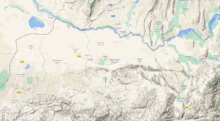
File:Bactria-Topographic-Map.png

Size of this preview: 800 × 439 pixels. Other resolutions: 320 × 176 pixels | 640 × 351 pixels | 1,024 × 562 pixels | 1,631 × 895 pixels.
Original file (1,631 × 895 pixels, file size: 2.12 MB, MIME type: image/png)
File history
Click on a date/time to view the file as it appeared at that time.
| Date/Time | Thumbnail | Dimensions | User | Comment | |
|---|---|---|---|---|---|
| current | 04:25, 15 November 2020 | | 1,631 × 895 (2.12 MB) | Terrydu (talk | contribs) | From Google Maps: https://www.google.com/maps/place/Balkh,+Afghanistan/@36.5825708,66.9330108,13.5z/data=!4m5!3m4!1s0x38cb52c3b19e9359:0x79479ff9f1496592!8m2!3d36.8909158!4d67.1894488!5m1!1e4 Category:Images |
You cannot overwrite this file.
File usage
The following page uses this file: