Greco-Bactria:Features: Difference between revisions
Jump to navigation
Jump to search
m Added image of just Bactria |
No edit summary |
||
| Line 13: | Line 13: | ||
* The climate is considered to be [https://en.wikipedia.org/wiki/Semi-arid_climate#Cold_semi-arid_climates cold semi-arid] steppe, "BSk" classification. | * The climate is considered to be [https://en.wikipedia.org/wiki/Semi-arid_climate#Cold_semi-arid_climates cold semi-arid] steppe, "BSk" classification. | ||
** In other words it evaporates more water than it rains. | ** In other words it evaporates more water than it rains. | ||
* Temperature: | **Notice the near total lack of vegetation, especially in the southern mountains. | ||
*Temperature: | |||
** In the valley, for example around the capital city of Bactria, the [https://en.climate-data.org/location/31385/ temperature ranges] from 32 F to 98 F (0 C to 36 C). | ** In the valley, for example around the capital city of Bactria, the [https://en.climate-data.org/location/31385/ temperature ranges] from 32 F to 98 F (0 C to 36 C). | ||
** It can have extreme temperatures [https://en.wikipedia.org/wiki/Mazar-i-Sharif#Climate as low as -22 C], and hence would be in [https://en.wikipedia.org/wiki/Hardiness_zone Hardiness Zone 6] in the USDA scale. | ** It can have extreme temperatures [https://en.wikipedia.org/wiki/Mazar-i-Sharif#Climate as low as -22 C], and hence would be in [https://en.wikipedia.org/wiki/Hardiness_zone Hardiness Zone 6] in the USDA scale. | ||
* Precipitation: | * Precipitation: | ||
** In the valley there is no [https://en.climate-data.org/location/31385/ precipitation] for about half the year, and then averages about 30 mm from January to April. | ** In the valley there is no [https://en.climate-data.org/location/31385/ precipitation] for about half the year, and then averages about 30 mm from January to April. | ||
* Topographic Map: https://www.google.com/maps/place/Balkh,+Afghanistan/@36.5825708,66.9330108,13.5z/data=!4m5!3m4!1s0x38cb52c3b19e9359:0x79479ff9f1496592!8m2!3d36.8909158!4d67.1894488!5m1!1e4 | *Topographic Map: https://www.google.com/maps/place/Balkh,+Afghanistan/@36.5825708,66.9330108,13.5z/data=!4m5!3m4!1s0x38cb52c3b19e9359:0x79479ff9f1496592!8m2!3d36.8909158!4d67.1894488!5m1!1e4 | ||
:[[File:Bactria-Topographic-Map.png|400px]] | |||
==Sogdia== | ==Sogdia== | ||
* Sogdia (acquired 5 years later when Alexander dies) is ... TBD | *Sogdia (acquired 5 years later when Alexander dies) is ... TBD | ||
Revision as of 04:30, 15 November 2020


Bactria
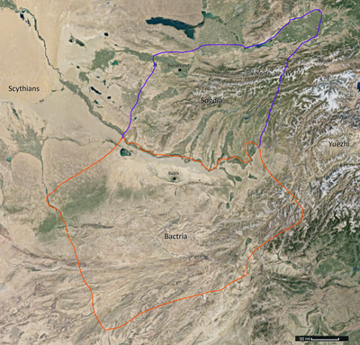
- Bactria is essentially a large east-west valley, situated between the Fann mountains to the north and the Hindu Kush mountains to the south.
- More precisely Bactria is bordered by the river Oxus in the north, which is just to the south of the Fann mountains.
- Arguably sections of the Hindu Kush mountains to the South are also part of Bactria, but other than containing horse nomads (who were insurgent during Alexander's time) it was not of interest.
- The land of Bactria is of three types, layered as east-west strips on top of each, starting from the south:
- Rolling hills (and the Hindu Kush mountains south of that)
- Alluvial plains (with occasional flooding) that produce abundant crops
- Desert (with occasional oases) just south of the river Oxus
- Sometimes Bactria refers to just this valley, other times it refers to the area that also includes the Hindu Kush mountains (such as at the time of Alexander's death), and other teams it includes both Bactria and Sogdia.
- Around BC 250 Bactria is said to have 1000 cities (somewhat of an exaggeration...)
- "Diodotus, the governor of the thousand cities of Bactria (Latin: Theodotus, mille urbium Bactrianarum praefectus)".
- The climate is considered to be cold semi-arid steppe, "BSk" classification.
- In other words it evaporates more water than it rains.
- Notice the near total lack of vegetation, especially in the southern mountains.
- Temperature:
- In the valley, for example around the capital city of Bactria, the temperature ranges from 32 F to 98 F (0 C to 36 C).
- It can have extreme temperatures as low as -22 C, and hence would be in Hardiness Zone 6 in the USDA scale.
- Precipitation:
- In the valley there is no precipitation for about half the year, and then averages about 30 mm from January to April.
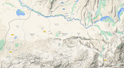
- Topographic Map: https://www.google.com/maps/place/Balkh,+Afghanistan/@36.5825708,66.9330108,13.5z/data=!4m5!3m4!1s0x38cb52c3b19e9359:0x79479ff9f1496592!8m2!3d36.8909158!4d67.1894488!5m1!1e4
Sogdia
- Sogdia (acquired 5 years later when Alexander dies) is ... TBD
